At the heart of IIT-M’s approach is a regional weather model trained to forecast rainfall at ward-level resolution of around four kilometers, a significant advance from traditional models that resolve only 25 kilometers.
Operational since late 2022 and run daily on National Supercomputing Mission machines, these forecasts—spanning seven-day horizons—are shared with Tamil Nadu’s disaster authorities and calibrated alongside a real-time flood forecasting system for Chennai’s basins.
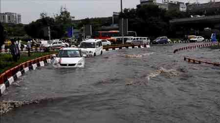
To strengthen these models, the IIT-M team developed a crowdsourced waterlogging portal, chennaiwaterlogging.org. This platform and a companion WhatsApp channel enable citizens to report flooded locations, water depth, and photographs in English or Tamil.
During Cyclone Michaung, more than 1,200 residents contributed data through the portal, helping shape a real-time heat map of inundation across the city.
The power of crowdsourcing shines through in how the data augments forecasting models. IIT-M researchers use reported water depths to validate and calibrate flood models, offering corrective feedback on both model predictions and the city’s stormwater infrastructure.
These findings help authorities pinpoint bottlenecks—like clogged drains or structural issues—and target remediation efforts more effectively.
While still evolving, IIT-M’s hybrid strategy of forecasting and community observation is already proving valuable. Institutional adoption of the Real-Time Flood Forecasting and Spatial Decision Support System, which integrates data from automatic rain gauges, weather stations, and water-level sensors, means flood alerts can now be predicted days in advance, giving officials time to act.
Beyond its immediate utility, the project symbolizes a shift in flood management—from reactive response to proactive preparedness. The blend of advanced weather modeling and real-world validation via citizen inputs closes a feedback loop that urban systems desperately need. If institutionalized and expanded, this model could reduce flood damage, optimize resource deployment, and build a digitally enabled civic infrastructure.
The path ahead will test IIT-M’s model in real-world conditions and its ability to scale. Enhancing input networks—increasing rain gauge density, expanding citizen participation, and automating sensor data—will be critical. But if Chennai’s daily forecasts and engagement tools hold steady through future monsoons, the city could evolve from flood crisis hotspot into a live laboratory for smart urban resilience.